Southwest Area Structure Plan Overview
What is an Area Structure Plan (ASP)?
An Area Structure Plan (ASP) is a high-level framework which guides future development of undeveloped lands. As a statutory document, enabled by the Government of Alberta, the ASP must describe:
- proposed sequence of development,
- general location of land use for the area,
- proposed population density of the area,
- general location of major transportation routes and public utilities, and
- any other requirements that Council may require.
ASPs are intended to ensure compatibility between the existing areas and the future developments of a particular study area. Once complete, the final ASP must be approved through a series of three readings by municipal City Council and a public hearing.
What lands are included in the Southwest Area Structure Plan (SWASP)?
The SWASP study area includes approximately 17 quarter-sections of land in the southwest portion of the City, with the westernmost lands directly abutting the County of Vermilion River. The rough boundaries of the SWASP include Highway 16 (north), 75th Ave (east), and 12th Street (south).
Project Update:
During the previous phases of the Southwest Area Structure Plan (SWASP) have been completed. Background research has been conducted for the study area, including a comprehensive review of the Municipal Development Plan – Connection to Our Future and various municipal master plans that will guide future land use within the area.
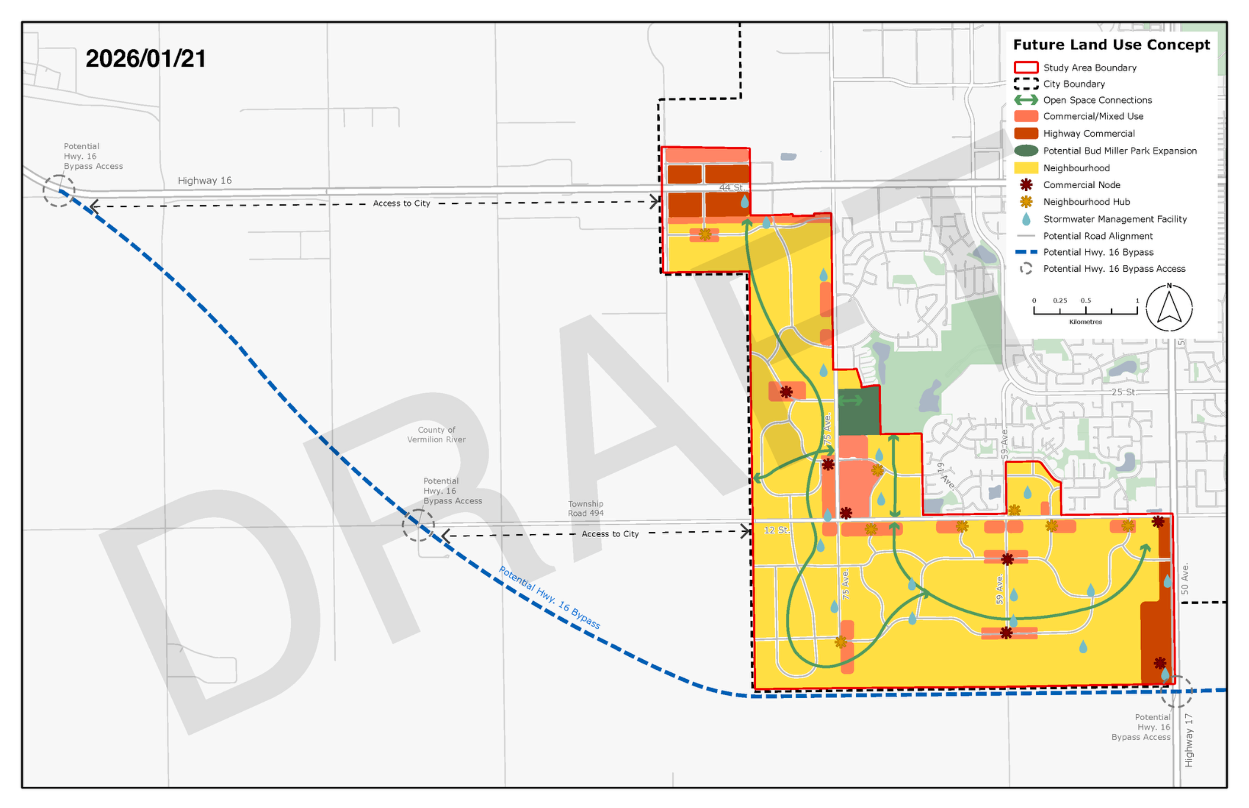
In terms of development, the project team has identified existing oil and gas infrastructure as the largest constraint in which established recommended development setbacks and suitable land uses in proximity to this infrastructure. Additionally, natural features within the area have been analyzed to determine how they could be incorporated into the open space concept and inform policy writing. The initial draft of the ASP document sections are underway, and the first draft of the future land use concept is complete.
The base maps (found in the right column for desktop users) illustrate the characteristics of the land and planned infrastructure. Please note, as a result of the initial engagement phase, the project boundary was adjusted. The preliminary maps indicate the previous boundary. All maps are subject to change. The future infrastructure maps were informed by the following plans:
- Stormwater Master Plan (2024)
- Sanitary Sewer Master Plan (2024)
- Water Master Plan (2024)
- Transportation Master Plan (2025)
The above master plans were utilized to guide the general layout of infrastructure within the study area. The project team has overlayed the proposed infrastructure with the MDP's guidance on the location of various land uses to establish the draft future land use concept. Alongside these technical master plans, the Bud Miller All Seasons Park Master Plan has been considered to determine how the park will influence the future growth of the area.
Next Steps:
During the current phase, Phase 3, the project team consulted with stakeholders and landowners regarding the preliminary land use concept and other influential factors. After understanding the perspectives of various stakeholders, the project team is welcoming public opinions on the land use concepts.
Get Involved:
Join us at the open house on January 29, 2026 between 4:30 and 7 p.m. at Servus Sports Centre. Those unable to attend the open house are encouraged to submit their feedback between January 29 and February 12 via the project page. Stay tuned for virtual engagement details. Paper copies are available at City Hall, Servus Sports Centre, Operations Centre, the library and Bioclean Aquatic Centre.
Learn more about local area structure plans at lloydminster.ca/ASP, or submitting a project-related question below.
Stay tuned for project updates and consultation opportunities by signing up for our engagement newsletter.
Digital Forum
What aspects of the draft Future Land Use Concept do you like?
What aspects of the draft Future Land Use Concept would you like to see reconsidered?
What are your project-related questions?
To ask a question you must create an account or log in.
These are the people that are listening and responding to your questions.
The Project Team
{{question.description}}


